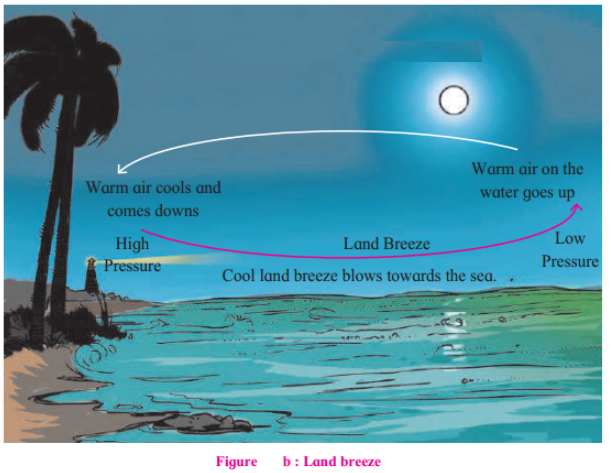
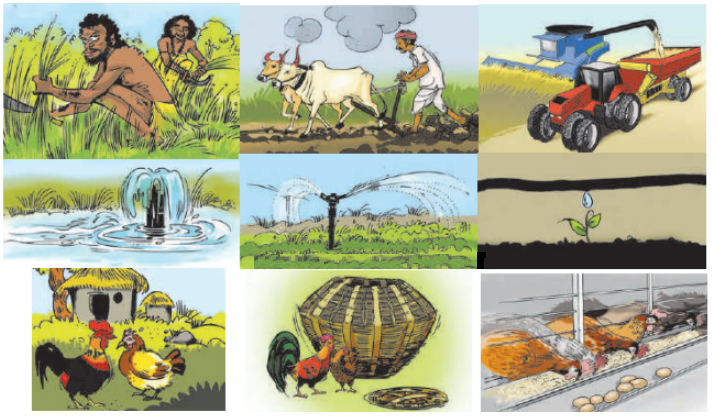
Question
  • Take three flower pots of the same size.
  • Keep one pot empty. Fill the second pot. With water after closing the hole at the bottom and fill the third pot with soil.
  • Put a few seeds in all of them. (You may use aserio, peas, gram, fenugreek, wheat, green gram, coriander seeds, etc.)
  • Keep all the three pots in the sun. and water the empty pot and the soil-filled pot for 4-5 days. Observe and answer the following.

(1) What happened to the seeds put in the empty pot and pot filled with water?
(2) What happened to the seeds put in the pot (c) filled with soil?
(3) What do you learn from this?

Answer

(1) Seeds in the empty pot and the pot filled with water did not germinate and did not show any sign of growth.
(2) Seeds germinated and we could see some small twigs branching out.
(3) We learn that plants need sunlight, water and soil to grow.

Need a full question paper?

Generate a complete, print-ready paper with questions like this in minutes — across 16+ boards, with answer keys.

Start Generating Free

Similar questions


Image
(1) Which pressure belt is mainly found in the Tropics?
(2) With which pressure belt are the polar winds associated? In which temperature zone are they observed?
(3) What could be the reason behind a low pressure belt in the Tropics?
(4) With which pressure belts are the winds in the Temperate zone associated?
(5) Write the latitudinal extent of the low pressure belts.
Observe the picture given below and answer the following questions.:

Image
(1) Which are the winds in the northern hemisphere that blow from the mid latitudinal high pressure belt to the equatorial low pressure belt?
(2) What is the direction of the Westerlies in the southern hemisphere?
(3) Which planetary winds blow from the mid-latitudinal high pressure belts to the subpolar low pressure belts in the northern hemisphere?
(4) Why is the direction of polar winds not the same in both the hemispheres?


Image

Image
(1) Compare fig.(a) and (b) with reference fo temperature conditions, air pressure and winds.
(2) Which winds are called sea breezes and which are called land breezes? Why?
(3) In which part of India are land and sea breezes experienced?
(4) Do you experience sea and land breezes in your area?
Observe Fig. and answer the following questions:
Image
(1) Name some of the settlements shown in the map.
(2) Which of the settlements in the map are in a scattered form?
(3) How are the houses in the settlements along the roads arranged?
(4) In which settlements are the houses close together? What could be the reason behind this density?
(5) Can you now classify the settlements on the basis of these pattern?
Figure shows the position of the earth with its tilted axis on 21st June and 22nd December. It also shows its illuminated and dark positions. Observe the figure and answer the following.

Image
(1) On which date will the Tropic of Cancer receive perpendicular sunrays?
(2) Considering the position of the north pole, which season will prevail in the northern hemisphere from 22nd March to 23rd September?
(3) The cricket matches in Australia are generally in summer, when does Australia have summer?
(4) In which period is the ‘midnight sun’ observable in Norway? Which season will there be at that time?
(5) At what time will the midnight sun be visible at the “Bharati Research Station” of India at Antarctica? What will be the season there at that time?

Observe the pictures and answer the following questions.
Image
(1) What differences do you observe these pictures?
(2) What changes have taken place in traditional agricultural practices?

Image

A 3D model is given in fig. (a) The northern part of the model shows the basin of the rivers Mula-Mutha. To its south is the Katraj. Diveghat range extending from the west to the east. Beyond that some portion of Karha basin is seen.
(1) Which part of the model is not seen in the map? Why?
(2) In which direction does the altitude of Katraj- Diveghat range decrease?
(3) In which direction are higher hill ranges located?
Observe the picture given below and answer the following questions.:

Image
(1) Name the winds that blow in the southern hemisphere.
(2) In which direction do the Easterlies blow in the Northern and Southern hemisphere?


Image

A 3D model is given in fig. (a) The northern part of the model shows the basin of the rivers Mula-Mutha. To its south is the Katraj. Diveghat range extending from the west to the east. Beyond that some portion of Karha basin is seen.
(1) In which direction does fort Purandar lie?
(2) What is the direction of flow of the river Karha?
(3) In which parts are the hill ranges not observed?

Image
(1) Which landforms do you seen in the model?
(2) Which colours have been used on them?