When one sees a landform on a contour map, what is the observer’s position with respect to landform? For example, a hill is shown with the help of contours on a map. From where do you think you are looking at it?
Question types
Contour Maps and Landforms question types
18 questions across 4 question groups — pick any mix to generate a Geography paper with step-by-step answer keys.
18
Questions
4
Question groups
5
Question types
01
Answer the question
1 Q→02Read the following extract and answer the questions below.
5 Q→03Answer in brief
6 Q→04FILL IN THE BLANKS
6 Q→Sample Questions
Contour Maps and Landforms questions
One sample from each question group in this chapter. Select any group above to see the full set with answer keys.
View full solution →
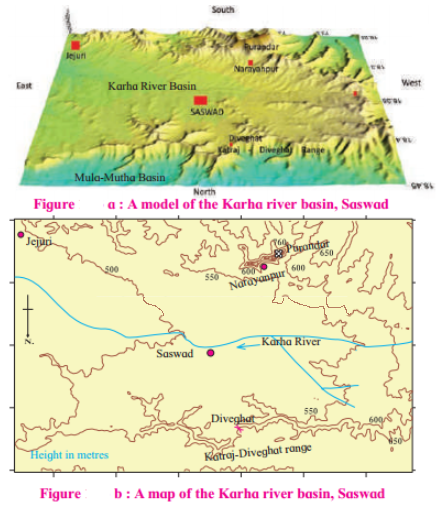
A 3D model is given in fig. (a) The northern part of the model shows the basin of the rivers Mula-Mutha. To its south is the Katraj. Diveghat range extending from the west to the east. Beyond that some portion of Karha basin is seen.
(1) Which part of the model is not seen in the map? Why?
(2) In which direction does the altitude of Katraj- Diveghat range decrease?
(3) In which direction are higher hill ranges located?
A 3D model is given in fig. (a) The northern part of the model shows the basin of the rivers Mula-Mutha. To its south is the Katraj. Diveghat range extending from the west to the east. Beyond that some portion of Karha basin is seen.
(1) In which direction does fort Purandar lie?
(2) What is the direction of flow of the river Karha?
(3) In which parts are the hill ranges not observed?
Model of the Earth’s surface:
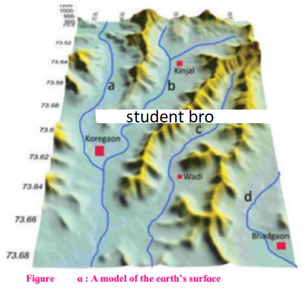
(1) What do these values indicate?
(2) Do you find any similarities in the map and the model in fig. (a)? What are those?
(3) Which figure give us more information and what is that information?
(4) Is there any similarity between this map and the sketch map of the potato hill?
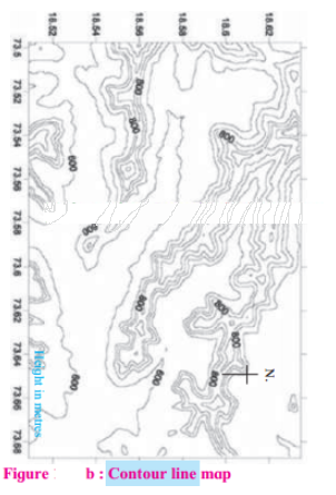
Model of the Earth’s surface:
(1) What all you seen in the map?
(2) What is the general direction of the ranges shown in the map?
(3) Towards which direction is the flat land located in the map?
(4) What are the maximum and minimum values of the lines in the map?
(1) Which landforms do you seen in the model?
(2) Which colours have been used on them?
How will a contour map be useful to a fanner?
What do you understand by observing contour lines?
To whom are contour maps useful?
How can the distribution of the height and landform in a region be shown?
Contour lines generally do not cross each other. Give reason.
If the distance between two contour lines is more then the ______ is gentle.
The slope can be understood from the distance between the ______.
The contour lines on the map represent ______.
If the contour lines are closer to each other, the slope is ______.
Generally, contour lines do not _______ each other.
Generate a Contour Maps and Landforms paper free
Pick question groups from the list above, set marks and difficulty, and export a branded PDF with step-by-step answer keys. First 3 chapters free — no signup.