On the topographical map these water bodies are shown in black colour.
Question types
Interpreting Topographical Maps question types
80 questions across 8 question groups — pick any mix to generate a Geography paper with step-by-step answer keys.
80
Questions
8
Question groups
5
Question types
01
MCQ
5 Q→02Fill in the blanks.
18 Q→03TRUE / FALSE
5 Q→04[1 Mark Question Answer]
19 Q→05[2 Mark Question Answer]
16 Q→06[3 Mark Question Answer]
8 Q→07[4 Mark Question Answer]
8 Q→08Match The Following.
1 Q→Sample Questions
Interpreting Topographical Maps questions
One sample from each question group in this chapter. Select any group above to see the full set with answer keys.
View full solution →
The green area in a topo sheet contains
This feature can be identified by a drop in height of the contours.
The contours for this feature are oval with contours close to each other indicating steepness.
The contour lines for this feature are evenly spaced in the form of concentric circles.
Houses or huts in $.........$ settlement are far apart from one another.
View full solution →The contour lines of a hill are evenly spaced in the form of $.........$
View full solution →Contour lines do not $.........$ one another.
View full solution →In a grid system of a topo sheet, the lines that run vertically are called $.........$
View full solution →A contour line is an imaginary line that connects all points having the same $.........$
View full solution →The spot height is indicated on the map with a small triangle followed by the number.
A gap is a low lying depression or a valley which cuts through a range of hills.
Contour lines are drawn at fixed intervals.
The lines that run vertically are called nothings.
A contour line is an imaginary line that connects all points having the same temperature.
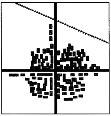
Identify the type of settlement shown in the picture.
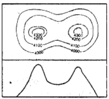
Identify the relief features shown by the following contour diagram
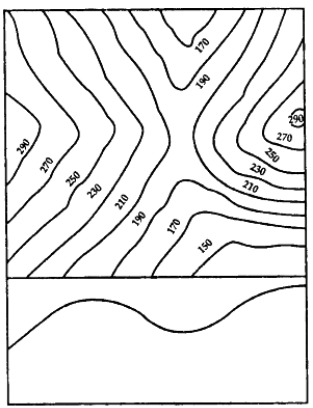
Identify the relief features shown by the following contour diagram
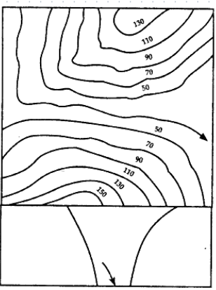
Identify the relief features shown by the following contour diagram
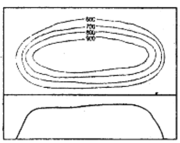
Identify the relief features shown by the following contour diagram
Explain permanent settlements.
What do you mean by settlements?
How would you identify the following on a topo sheet: Gap
How would you identify the following on a topo sheet: Pass
How would you identify the following on a topo sheet: Col
Explain temporary settlements.
How are topo sheets prepared for India?
List some basic characteristics of contour lines.
What do you mean by eastings and northings in a topographical map?
Where are $V-$shaped valleys and $U-$shaped valleys formed?
View full solution →Write two characteristics of this type of settlement.
What are the three main types of settlement patterns on a topo sheet?
Explain the two types of grid references.
Mention features of a grid system of a topo sheet.
List the aspects that you should keep in mind while studying a topographical map.
| Column $A$ | Column $B$ | ||
| $1$ | $45D/7$ | $a$ | To begin reading at topo sheet |
| $2$ | South$-$west corner | $b$ | Depression |
| $3$ | $\triangle 217$ | $c$ | topo sheet number |
| $4$ | White portion in a topo sheet | $d$ | Triangulated station |
| $e$ | Barren land | ||
Generate a Interpreting Topographical Maps paper free
Pick question groups from the list above, set marks and difficulty, and export a branded PDF with step-by-step answer keys. First 3 chapters free — no signup.